Wednesday 18 April 2012

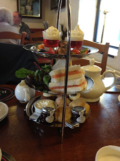
Afternoon Tea at the Ramblers Bar.

We found the Ramblers Bar attached to the Inn on the Lake in Glenridding.

As you would hope from the name, the bar is walker, dog and child friendly, its warm with a big roaring fire and has a nice selection of ales on tap. We found the flat screen TV tuned to a music channel a bit distracting but they were showing the football when we went in the evening, so worth remembering if you are camping and need to keep up with the sports news.

There is an extensive pub style menu that looked reasonably priced and the meals being delivered to other tables looked to be of a good size and quality.

We opted for the afternoon tea (this was James' way of bribing me to get up and down Little Mell in 30 mins!)

Its fairly pricey at £15.50 per person but comparable with other places such as Betty's and to be expected in a village where there is not much other competition.

Instead of getting a selection of sandwiches we were given option of choosing one from salmon, cheese, ham and tuna. James had cheese and pickle and I had salmon. These came with a nice bit of dressed side salad. I was a bit disappointed that my salmon sandwich lacked any kind of dressing or cream cheese however who really gets afternoon tea for the sandwiches?


The scones were spot on, however they were served with double cream rather than clotted cream which distressed me a little. The miniature Victoria sponge and Grasmere cake were fantastic and loads of fun. We also enjoyed the mini chocolate éclair and trifles.


Another only slight criticism was that three of the items consisted of strawberries and cream, maybe a lemon cake or a chocolate mouse to add some variety?

The presentation was perfect and the large tea pot was topped up with hot water meaning we had plenty to drink.

The atmosphere was nice enough in the bar, but it looks a little sparse and you have to order at the bar. If you were to arrive in nice clothes rather than muddy boots and waterproofs like we did you could sit in the hotel lounge. It looked very smart from what we saw through the windows!

I think I have been a bit harsh here with the nit picking, this was a really good afternoon tea, I just eat a lot of afternoon tea and know what I like with regards the finer details.

I rate my afternoon teas using the 'T factor' which is:

                                                             Score out of 20/Price in £

The scores:
Ambiance: Cosy and comfortable but room shared with a noisy tv! 3/5
Service: Good but basic- orders made at the bar 3/5
Presentation: 5/5
Food quality: 5/5

Price £15.50 each

                                                           16/15.5 = T factor: 1.03


Its a bit of a low score due to the price, nevertheless we had a lovely tea and getting dressed up and dining in the hotel lounge would have been great.

The Ramblers Bar
Inn on the Lake,
Lake Ullswater,
Glenridding,
Cumbria,
CA11 0PE

017684 82444

K.

Gobarrow Fell


Gowbarrow Fell - 481m (1,578')
Completion Date: 12.04.12
ROUTE


This fell shows more about what we are trying to achieve more than any of the previous fells. It would have been easy for us to attempt the short ascent from Dockray, but as AW says, "[it] is much less attractive." So instead we decided to follow AW's suggested route, taking in the panoramas of Ullswater.

The walk began with us with parking at the car park for Aira Force; a National Trust car park that unless you're a NT member you'll have to pay for the privilege to park there (£4.00 for up to 2 hrs, £5.50 between 2 & 4hrs, and £6.50 for over 4hrs). We tried to find free parking nearby but as we were on a bit of a deadline we settled for the car park.

The walk began with us leaving the car park and heading up towards Aira Force. We took the first bridge to our right across the beck and followed the fence enclosing the area up and round until we quickly found ourselves leaving the wooded beck and heading through the gate towards the foot of the hill. The picturesque waterfall would have to wait until we had conquered the fell.

With the southern slopes to our left and Ullswater to our right we began to ascend the well maintained pathway up towards Yew Crag. This route offered spectacular views of Ullswater and a clear view of one of Wainwright's favourite walks around the foot of Place Fell, "It is the author's opinion that the lakeside path from Scalehow Beck near Sandwick, to Patterdale (in that direction) is the most beautiful and rewarding walk in Lakeland." - I can't wait to do that walk on a summer's evening this year, I just need to figure out a way of keeping the beer in the tent nicely chilled for our arrival back to Side Farm Campsite, but I digress....
Stunning views back across Ullswater
We climbed the path to the walk's intermediary summit of Yew Crag. Walking around the crag offered a change of scenery as we turned away from Ullswater. The path is well walked (and maintained) and undulates around the eastern flank of the fell crossing small streams and crags. We passed a couple of groups who were obviously doing their D of E and looked truly fed up. I can only hope that our cheery "Hellos" and smiling nods did something to help spur them on along their walk?

The path eventually lead to a gate in the wall which was crossing our path and the remains of the old shooting lodge. This is where our path broke away from the path on the OS Map, but as we were finding out, if AW suggested a good route to walk, it will inevitably be walked and therefore easy for us to follow, which it was.
Remains of the shooting lodge indicating the turning point from the OS Path
The path from the shooting lodge takes us once again to a different environment and scenery. The walk gradually ascended into the peaty, boggy ground that inhabits the top of the fell. Following the wall that encapsulates the northern edge of the fell we found evidence of the maintenance of the paths, with freshly dug drainage channels and slabs of local stone laid to help the fell's visitors avoid the deeper, muddier sections of the bog. A nice sympathetic piece of landscaping, if only there was a peat bog in our new garden...!

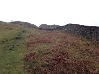
Our 1st glimpse of Gowbarrow Fell
The peat landscape started to become punctuated with rocky outcrops as we approached our destination. A small climb up and around to the right of the rocky mound pictured above brought us to the summit of Gowbarrow Fell.
Look! It's no longer a cairn!

Showing a bit of leg...
The summit offered good views across to the Helvellyn range and as the weather was clearer than previous days we could pick out our proposed ridge route from St. Sunday to Fairfield, which looked pretty awe inspiring. A dramatic drop-off and climb!

On leaving the fell top we headed due south. The path initially follows to the left of the next set of rocks and is easy to pick out. There are many smaller intersecting tracks across the top of the fell, but once again, the major route is well walked and can be picked out from the rest. The route cuts back and forth, but on a clear day Place Fell can be seen in the distance with the protuberance of High Dodd being a good guide to head towards. In poor visibility care should be taken as this route does take you on a course straight over the edge of Yew Crag! But as we found out, the point where the path strikes right off the summit plateau and  down the shoulder of the fell towards Aira Force, a cairn has been constructed to instruct lost walkers of this junction.
The cairn on above Yew Crag telling you to turn right!
The descent was fairly rapid in contrast with the rest of the walk and a bit of a tester for the quads after 3 days walking. But the prize at the end was the very beautiful Aira Force. A series of waterfalls feeding into Ullswater. Aira force is a real tourist trap and a bit of a shock having spent the past few days sharing Lakeland with only a limited number of fellow walkers. But we bustled our way through the crowds to appreciate the falls and take a few photos.
Katie marvelling at the wonders of a stream!

Aira Force

The main waterfall plummeting through the rocks

Some old-school graffiti 
And there concluded our last walk of the trip. With the promise of a quick brewery tour of Hawkshead Brewery (one of Katie's friends conveniently works there, bonus! - *try the Pale & the Cumbrian 5 Hop, both really good) we clambered back into the car and made our way out of the Lake District a little wiser and definitely hungry to come back as soon as possible and explore more of what Lakeland has to offer!
Until next time!
J.


Tuesday 17 April 2012

Summit Snacks: Samuel Valentine pies

The hills do indeed have pies, our first Summit Snack we took with us from home as we weren't sure what we would find when we arrived in the Lakes.

Samuel Valentine is an ace deli in the village of Allerton Bywater just outside Leeds. They have a huge range of produce including cheeses, local beers, jars of pickles and preserves and of course pies.


We consumed the Samuel Valentine pie on the summit of Birks, it featured nice crisp pastry, well seasoned meat and not too much jelly. Warning: this pie does not do too well after 3 days in a back pack with a brown banana.

Samuel Valentine
20 - 24 Station Road
Allerton Bywater
Castleford
WF10 2BP

Website

K.

Sunday 15 April 2012

Little Mell Fell

Little Mell Fell - 505m (1,657')
Completion Date: 11.04.12
ROUTE


THE 30 MINUTE FELL

This fell is even smaller than than the last one (Great Mell Fell). With a height difference of only 125m from the start point to the summit there isn't a great deal to the walk. It's very straight forward route to the top of the grassy fell with only a small section of the track traversing the the fell half way up to break up the route directly up the fell.

So with this in mind I set us a challenge of obtaining the fell and getting back to the car in under 30 minutes.
The first view of the trig point on top of Little Mell Fell
Although this fell is one of the smaller more isolated fells, Wainwright states that, "There is good in all, however, and its heathery top is a fine place for viewing the (greater) merits of the other fells." Alas though the clouds and rain had well and truly closed in meaning that we could see pretty much nothing.
Fell top trig point

Conquered!
After the photos were taken we checked the time and made our quick descent down the fell. I must admit that I jogged the descent to assure that I made the challenge time!

A quick dry off and fell #4 under our belt. Job Done!

J.

Final time: 28 minutes

Great Mell Fell

Great Mell Fell - 537m (1,762')
Completion Date: 11.04.12
ROUTE


The previous days tramping through the snow had taken its toll on some of our equipment. In particular, Katie's boots. They were soaking inside and out having had some sort of catastrophic waterproofing fail. So our first task was to try and find an outdoor shop and buy some new kit.

We headed over the river to Glenridding where we dropped into Catstycam Outdoors Shop. A clearance sale of last year's stock meant that we saved around 50% overall on our purchases (I love a bargain). The staff were really helpful and keen walkers themselves which meant that the information they gave was informative and knowledgeable. They have a good choice of stock tending to be of higher end specifications, so not budget equipment that lasts a short while before breaking or not being up to the task.

So, with the new boots, waterproofs base layers and various other shiny new things, we decided to test the equipment out on a couple of smaller fells (as it would suck to be up on top of Helvellyn with new boots that are rubbing). We decided to do the Mell Fell's, Great and Little.

After a short drive we found the lay-by at the south eastern base of Great Mell Fell. The weather was a contrast to the previous day with large swathes of blue sky visible and a gentle cooling breeze, perfect for walking.

Great Mell Fell is pretty straight forward, with a limited choice of ascents and descents. We followed the track along the southern edge of the wood and after a short while climbed over the style to start the ascent. We followed the path shown on the OS Map clockwise around the base of the fell until just after leaving the woods we found the track to our right that marks the ascent onto the fell top. Although the track isn't marked on the OS Map it is regularly walked and easy to follow.

Wainwright suggests taking a meandering route that follows the edge of the woods. It is clear that most people tend to choose a more direct route straight to the top as this route is clearly more used and worn out, however we are keen to make this Wainwright Bagging challenge about the walks as well, and not just simply ticking off a series of numbers. So we took the chance to change the gradient of the walk and take in some scenery, I mean, who are we to argue with AW?
First view of the summit.
As we approached the summit of the fell we could see the clouds in the distance rolling in. We hurried to the top in order to take in the views of the surrounding fells. Unfortunately the clouds beat us and we could only pick out some of the snow capped peaks in the Helvellyn range.
Great Mell Fell summit cairn

Hooray!
The descent off the grassy fell top was same route as the ascent, offering views of the north side of Little Mell Fell with its gorse bushes in full flower.

With the kit performing well we made it back to the car and set off towards our next destination, Little Mell Fell.

J.

Look What We Found Review

We were sent a few samples from the new 'Look What We Found' range of ready meals to review as camping food.

These are the selling points:

All natural ingredients- we checked the ingredients list and yes the ingredients list read like a recipe rather than a scary list of E numbers and preservatives.

Supporting British farmers- LWWF claim that they source all of their produce from the UK. Excellent.

Long shelf life- LWWF foods are pressure cooked from raw inside the packets meaning that all meals have a shelf life of a year and can be stored at ambient temperature. Very convenient and the packets feel very sturdy, I don't think you would have to worry about these bursting in your bag.


What we thought:

There is a good range of traditional meals available. The packets just tore open and we squeezed them in to a pan. The packets were light weight and folded up to nothing when empty. We found that the meals heated up very quickly which was good for fuel consumption and tasted absolutely delicious! The chicken tikka was not hot but had a rich delicate flavour and the stews really tasted like home made. The meat was melt in the mouth. The claim that all the flavours are retained in the packet is really true.


Now the criticisms.

Weight: This food is 'wet food', fine if you are in the car and going back to camp each night but a waste of weight if you are taking everything with you.

Calories: This food is not very calorie dense, even the tikka with the creamy sauce only came in at 335 calories per packet. This is fine if you are sitting reading/ fishing or going for tours of the Keswick Pencil museum, but after a long hill walk we virtually inhaled the lamb and mutton stews (238 and 216 calories in those). We padded the venison meal out with pasta and that worked quite well for a meal for two but diluted the flavour considerably.


Price: These meals are priced at between £2 and £3 per packet. They are far superior to canned food in packet weight, convenience and flavour but you pay for that superiority. Also I could have easily eaten two packs of the mutton stew and still been hungry. For the £6 that would cost you may as well go down the road to the pub and get a meal there.

Our conclusion- the food was truly fantastic and tasted like home made. We found them very convenient and fuel efficient to store and reheat. The only thing that would put us off in the future would be having to buy 2 each to fill us up!

Great for those with small appetites or big pockets. For everyone else maybe have these as a treat to break up the monotony of cans of beans and sausages!

Look What We Found Website.

K

Friday 13 April 2012

Arnison Crag & Birks

Arnison Crag - 433m (1,421')
Birks - 622m (2,041')
Completion date: 10.04.12
Pie: Pork Pie (from Samuel Valentine The Urban Food Hall, Allerton Bywater)


The first walk...

As I described in my earlier post, I wanted to bag Arnison Crag as my first fell as it was also AW's first. The walk I had drawn up was an 8.9mile circular route from Patterdale taking in Arnison Crag, Birks, St. Sunday Crag, Fairfield, Hart Crag & Hartsop above How. Here is the route.

However, due to adverse weather conditions approaching St. Sunday Crag we had to turn back! This was a pretty big decision at the time, but common sense (or Katie as I also know her) prevailed. If we were to continue it could have landed us in a situation that could easily have gone very wrong. The conditions underfoot were poor; the snow although looking fresh & crisp, was beginning to melt under the top layer making it very slippery. The snow had blanketed the fell meaning that even in clear conditions it was virtually impossible to find the path leading up to St. Sunday and we had no idea what the conditions were further into the range. Finally, the wind whipping over the fell tops was hurtling hailstone straight at us and bringing thick cloud down with it too meaning that visibility was dropping the closer we got to St. Sunday. So as much as I would have loved for the first walk to have bagged some of the bigger fell tops, it was just not meant to be. They're not going anywhere so they'll still be there for another try.

In the end we turned back after Birks and descended back to Patterdale. This is the route we took: Arnison Crag & Birks.

I must admit that after orientating myself from the campsite, looking across the river and working out which of the looming hulks of rock we would be trying to climb, it was very daunting. I've climbed hills in the Yorkshire Dales before and I've done a couple of walks in the Lakes, but I've never attempted any fell tops.

After a quick breakfast we set off across the river towards the hotel in Patterdale. The path towards the fell took a couple of moments to find as it begins in the back car park (to the right hand side as you look at the front) of the hotel. The steady climb began there until we reached the style in the wall. This is where our route turned towards our first summit. Following the wall (keeping it to our right hand side) we quickly learnt that walking in the Lakes is a whole different beast. The path climbs steeply past Oxford Crag, a good initial vantage point back across Ullswater and to the campsite and a great place for us to catch our breath. The climb continued upwards past the remains of a decomposing sheep (I will save you from the gratuitous picture) towards our first fell top destination.
First view of Arnison Crag
To get onto the fell top we followed the track around to the south-west of the crag and after a small scramble we had achieved our very first fell! It felt great! But the realisation that there were still 213 fell tops to go, and this was only one of the baby ones was not lost on us. It is going to be a huge task.
Pointy
Hooray!
Adding our rock to Arnison Crag cairn
Our next task was Birks. The route from Arnison Crag took us around the large hillock to meet the wall once again that lead us to Trough Head (description in the notes of the walk). The ascent alongside the broken wall was tricky. We had reached the level of the snow and thus had lost any clear view of a track. We followed the broken wall as far as it went, but the melting layer of snow under the top crust meant that both of us had our fair share of falls and slips. A mental note was made to investigate the pros & cons of trekking poles!

Once the wall had finished we headed in the direction of the fell top at Birks (with the help of the GPS on the iPhone - Cheating? Maybe? - Quicker than map & compass? Yup!). We intersected the path that led us finally to Birks.
First view of Birks fell top
The fell top itself was pretty uninspiring considering the climb to get there. And I'm sure that in better weather conditions that the views are amazing. But we couldn't say as visibility was getting worse.
More pointy

More Hooray! (...trend?)
It was at this point that we attempted and St. Sunday Crag and decided to turn back. As I said, it'll still be there another day... So, our route took us back towards Patterdale and down the shoulder of Birks. I had been warned by my friend John that this route was very steep, but being stubborn and obviously knowing best I thought he was just being melodramatic... It turns out though that it is really steep (another occasion for those trekking poles?) but it does offer some pretty spectacular views. On the other side of the valley towards the howling pack of dogs in the kennels we could pick out the ascent up to the Hole In The Wall that we will be doing to get to Striding Edge and eventually Helvellyn... But that is for another day also!

After a good old work out for the quads, and a bit of punishment on the bad knee, we reached the road that winds down into Patterdale and this is where I found the silver lining on having to turn back early. If it wasn't for of our impromptu change of route, then I would never have passed this wonderful banner:
Pint anyone?
In reflection it was a great walk. It may have been shorter than we originally planned and there was definitely disappointment in not being able to make the original walk, but we had our first 2 fells under our belt and we had undergone a steep learning curve. But at least I'm still here typing this and not still lost on the fells!

St. Sunday, we shall return. And Patterdale Playing Field, we will be back for your wonderful beery offerings!

J.

The 1st Camping Trip


Now we're home from our first trip to the Lakes, just about intact, and a little wiser as to what's in store for us.

We arrived late on Bank Holiday Monday (09.04.12) and pitched up in fading light, just in time to avoid the heavy shower that hit us. We wanted to use this trip to get a feel for the challenge that is in store. The aims were to assess the area which will be exploring and walking, to test our equipment and to try some of the planned walks to gauge the routes/ distances/ terrain/ weather conditions etc.

The things that we found were:

  • No matter how many times you hear, "The weather can change through all seasons in a moment on the Fell tops." does not prepare you for when it actually happens!
  • The only thing that could potentially outnumber sheep in the Lake District is BMW Estate cars
  • Chinook helicopters are not conducive to an afternoon nap (but they are really cool!).
  • Low flying fighter jets practising manoeuvres through the valleys give you childlike levels of excitement.
  • The hills are always much steeper when you're climbing them rather than just looking at them.
  • Rock pegs are a god-send when camping in the Lakes (note - must bring a hammer next time).
  • Bananas spoil the taste of delicious pies when they're stored together.
With regards to the walking, the one thing that we noticed was that the usual time scales that we apply to walks need to be severely reconsidered. Having done a lot of walking in the Yorkshire Dales I can pretty confidently look at a walk on paper, take in the distance and terrain, and then predict the walk duration. We quickly found that is not the case when walking the severe slopes & terrain of the Lake District. Granted, our fitness levels will improve over time, but until that happens, we will have to be more realistic about what can be achieved in a single day of walking.

The second major element to judging walking in the Lakes is just how different the weather conditions and terrain underfoot is once you start to approach the higher altitudes. We found out first hand not to assume that the walk will be possible just because the going is easy in the valley bottom. Paths can quickly vanish under a carpet of snow leaving you scratching your head as to which way to negotiate the crags and scree slopes, and visibility can vanish in a matter of minutes. The combination of these two things could easily turn your walk into a feature length episode on 'Helicopter Heroes'.

All in all though we had a fantastic trip and we can't wait to get back out there to continue the adventure!

J.

Wednesday 14 March 2012

Where To Start?

Having had time to absorb some of the information in the guides, I needed to decide where to start my "bagging".

This has been harder than it seems.

People who know me, and my mild OCD, will know that I need things to have an order. A reason. Rules... I mean, think of the chaos if you listen to your stereo with the volume on an odd number (multiples of 5 obviously the exception). Why would you not drink your beers in ascending percentage order? You have instructions inside Kinder Eggs for a reason! Etc, etc, etc.

So, after leafing through the 7 pictorial guides I considered several options of what should be the 1st fell I bag? There's Blencathra, the mountain that first sparked my interest. Helvellyn, a mountain that I missed walking up when I was younger (with a walking group) because I was away on a family holiday. Or Scafell Pike, the highest mountain in England.

But I found myself looking at the very first fell in Wainwright's first pictorial guide, The Eastern Fells. The fell in question is Arnison Crag, "A low hill with a summit worthy of a mountain." as described by AW. The crag overlooks Patterdale, and the village shop that was the first place to ever sell AW's pictorial guides. Arnison also starts with an "A", which is the first letter in the alphabet (tenuous I know).

With all of these "firsts" it seemed like a logical place to begin. So out came my pen and paper and I began to plot a route that would take me up past Arnison Crag, Birks and onto St Sunday Crag. A ridge walk and climb to Fairfield will then be followed by a descent taking in Hart Crag and Hartsop Above How before returning to Patterdale.

With the first potential 6 fells neatly wrapped up into a walk, I continued to plan several other walks in and around the Patterdale area. I then checked my diary and Katie's diary before booking time off work. All that remains is to cross our fingers and hope for moderately decent weather (you can always hope?!) and look forward to the walking.

J.

--- Once the walks have been completed I will aim to post the maps and .gpx files of the routes ---

Monday 20 February 2012

In the beginning...


So this is where it all begins, a newbie to blogging and the start of my “Wainwright Bagging” adventure.

It’s Monday evening in late February. The collection of Wainwright pictorial guides arrived through the post just before the weekend, but due to a trip away with the lads in Wales quad biking, go-karting and the partaking of maybe a little too much of the local ales, I’m only just settling down to read the books now.

I began walking/ hiking when I was in the cub scouts and I’ve been doing it on and off ever since. The walks I’ve done in the past have been mainly in The Yorkshire Dales or The Pennines. I’ve done 1 or 2 walks in the Lake District but nothing too serious. And I was content for this to continue to be the case were it not for a series of occurrences that started to fan the flames of what has now become my new challenge…

  • The first occurrence happened a few years ago when I briefly stumbled across the TV show “Wainwright Walks”. Although I found the show interesting and the aerial views of the hills & mountains stunning, it was nothing more than a mental note of – ‘I must do some of them someday’.
  • The 2nd occurrence was when I was doing some training in Scotland for part of the apprenticeship that I’ve recently finished (probably the oldest apprentice ever). The 4 weeks I spent training up there meant that I had 4 return trips from Leeds to Falkirk to drive. I decided to mix journeys up and take different routes and detours on different weekends, and one of those routes happened to take me along the A66 and past the magnificent Blencathra. The sight of her looming over the landscape with a dramatic backdrop of storm-clouds approaching in the late October dusk was awe inspiring. I couldn’t shake the image from my head and it was at that point that I knew for certain that I was going to climb her. On arriving home I vaguely remembered a TV show about that mountain and by racking my terrible memory I finally found myself online buying series 1 & 2 of Wainwright Walks with the idea that it would give me a few tips and ideas when I finally get round to doing the walk.
  • The 3rd occurrence came soon after when I was chatting to a contractor at work who I have semi-regular dealings with. We were talking about walking and he was telling me in particular about his recent trip to Scotland with work and the walks he’d done whilst there. He mentioned the term ‘Munro Bagging’ which he explained to me was climbing all of the listed Munros. He also mentioned that there is a similar challenge in the Lake District (a little closer to home, so a touch more appealing). I was time for me to go home and finish watching those DVD’s…

The final piece of the jigsaw came after doing a few walks in the Dales with my lovely other half, Katie (check out her blog - http://leedsgrub.blogspot.com/ ), I suggested doing the “Wainwright Bagging” challenge, and she said that she’d like to, so here we are!

My aim is to walk and achieve all 214 of Wainwright’s fells. There’s no time limit. No order. No rules about ascending/ descending the fells beyond that I have to do it on foot and I cannot claim to have “bagged” the summit until I have stood there.

I’ll write about the walks, campsites, cafes, beers drunk, pies eaten, and any things that may or may not be of any use to anyone beyond the fact that it will kick start my beer-soaked memory into remembering what I’ve actually been up to. And you never know, it may just be the spark needed to get you up there too?

See you on the hills!